
By Jennie R. Ebeling
Associate Professor of Archaeology
University of Evansville
By Norma Franklin
The Zinman Institute of Archaeology
University of Haifa
August 2012
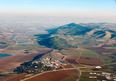
Members of the Jezreel Expedition headed by co-directors Norma Franklin (Zinman Institute of Archaeology, University of Haifa) and Jennie Ebeling (Department of Archaeology and Art History, University of Evansville) conducted an intensive landscape survey of “greater Jezreel” in June 2012. The main goal of the inaugural season was to record surface features in a three square kilometer area to the west, north, and east of Tel Jezreel in order to identify areas for excavation in summer 2013 (Figure 1). The Jezreel team documented more than 360 features, including cisterns, cave tombs, rock-cut tombs, agricultural and industrial installations, terrace and village walls, quarries and more; most of these features had never been systematically recorded before. The results of this survey shed light on the extent of different settlements at Jezreel from late prehistory through to the 20th century CE Palestinian village of Zer’in.
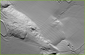
In preparation for the 2012 season, maps, plans, aerial photographs, and various other unpublished materials relating to the site were collected from sources in Israel, Great Britain, and elsewhere. In February 2012, The Jezreel team commissioned a LiDAR (light detection and ranging) airborne laser scan of ca. 7.5 square kilometers of greater Jezreel from Ofek Aerial Photography, Ltd. The LiDAR scan provided us with accurate locational and height data that enabled the creation of a three-dimensional model of the land surface (Figure 2). The resultant model was examined to identify historic and natural features and georeferenced with aerial photographs (the earliest of which dates to 1918); this provided us with data concerning the landscape before mechanized farming and other modern surface-changing events took place. This is the first time that aerial LiDAR has been used by an archaeological project in Israel.
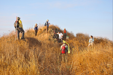
Land to the west, north, and east of the tel was divided into survey areas based on the LiDAR model; when possible, natural, and modern features delineated these large areas. Each identified feature was assigned a locus/feature number and information was recorded along with one or more sketch plans on a locus sheet. Coordinates and elevations were taken for each feature using a handheld GPS (Garmin eTrex HC), and a digital camera was used to document each feature from several angles (Figure 3).
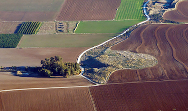
Since the goal of this survey was to identify surface features, pottery and other artifacts were not systematically collected other than in Area T , located on the terrace that overlooks ‘Ein Jezreel (the spring) (Figure 4). Pottery, lithic, and ground stone artifacts were collected on the terrace to the west and the east of the masha, or uncultivated area that was too overgrown to properly survey, designated Area S. To the west of the masha, the team collected pottery from the Early Bronze, Intermediate Bronze, Middle Bronze, Iron Age, Roman, Byzantine and modern periods; to its east, Wadi Rabah, Chalcolithic, Early Bronze, Intermediate Bronze, Iron, and Byzantine pottery was collected. This information, along with the results of earlier surveys conducted by N. Zori and members of the Tel Aviv – British School of Archaeology excavation team in the 1990s led by P. Croft, suggest that the site was inhabited continuously from as early as the late Neolithic period until the Byzantine period. The team plans to open an excavation area on the terrace in 2013 in order to investigate the occupational phases of this lower site. Other excavation areas are also planned in selected areas on the tel and on the north and east slopes.
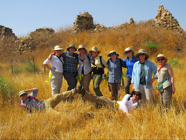
The 2012 Jezreel Expedition team included Norma Franklin (University of Haifa) and Jennie Ebeling (University of Evansville), Ian Cipin (University College London), Julye Bidmead (Chapman University), Noga Blockman (Tel Aviv University), and Deborah Appler (Moravian Theological Seminary) along with eight archaeology majors and alumni from the University of Evansville: Megan Anderson, Nathan Biondi, Sarah Carlton, Emma Dunleavy, Kelly Goodner, Michael Koletsos, Emily Mella, and Hilda Torres (Figure 5). John Egerton, Deborah Graf, and Rebekah Thomas of Moravian Theological Seminary participated for several days, as well did Jeff Anderson (Wayland Baptist University), Willie Ondricek (University of the Holy Land), and Daria Trumbo. Technical support was provided by Peter Ostrin (University of Leicester) and Matthew Bradley in Oxford. The team wishes to thank former co-director of the Tel Jezreel Excavations David Ussishkin (Tel Aviv University) as well as Mina Weinstein-Evron and Michael Eisenberg (University of Haifa) for their support of this project, and Deborah Cantrell (Vanderbilt University), Shimon Gibson (University of the Holy Land) and Eran Arie (Tel Aviv University) for their advice and assistance. We have benefited from cooperation with the Megiddo Expedition and the generosity of directors Israel Finkelstein and David Ussishkin (Tel Aviv University) and Eric Cline (George Washington University). We also wish to thank Sheila Bishop, President of The Foundation for Biblical Archaeology, for her generous assistance. The Jezreel team lodged in the Partnership House at Kibbutz Yizre’el for the month of June and enjoyed the warm hospitality of kibbutz members.
For more information about the Jezreel Expedition, please visit our website: www.jezreel-expedition.com
Figures 1 and 4 courtesy of Todd Bolen.
Comments (1)
Extremely interesting expedition. Looking forward to hearing results of the 2013 dig.
#1 - judy goldman - 08/22/2012 - 08:32